Póster Presentado en :
Geophysical Research Abstracts
Vol. 15, EGU2013-5611, 2013
EGU General Assembly 2013
© Author(s) 2013. CC Attribution 3.0 License.
Validation of MODIS aerosol optical depth over the Mediterranean Coast
J. Vicente Díaz-Martínez (1), Sara Segura (1), Víctor Estellés (1,2), M. Pilar Utrillas (1), and J. Antonio Martínez-Lozano (1)
(1) University of Valencia, Burjassot, Spain, (2) University of La Laguna, San Cristóbal de La Laguna, Spain
Atmospheric aerosols, due to their high spatial and temporal variability, are considered one of the largest sources of uncertainty in different processes affecting visibility, air quality, human health, and climate. Among their effects on climate, they play an important role in the energy balance of the Earth. On one hand they have a direct effect by scattering and absorbing solar radiation; on the other, they also have an impact in precipitation, modifying clouds, or affecting air quality.
The application of remote sensing techniques to investigate aerosol effects on climate has advanced significatively over last years. In this work, the products employed have been obtained from the Moderate Resolution Imaging Spectroradiometer (MODIS). MODIS is a sensor located onboard both Earth Observing Systems (EOS) Terra and Aqua satellites, which provide almost complete global coverage every day. These satellites have been acquiring data since early 2000 (Terra) and mid 2002 (Aqua) and offer different products for land, ocean and atmosphere.
Atmospheric aerosol products are presented as level 2 products with a pixel size of 10 x 10 km2 in nadir.
MODIS aerosol optical depth (AOD) is retrieved by different algorithms depending on the pixel surface, distinguishing between land and ocean. For its validation, ground based sunphotometer data from AERONET (Aerosol Robotic Network) has been employed. AERONET is an international operative network of Cimel CE318 sky-sunphotometers that provides the most extensive aerosol data base globally available of ground-based measurements. The ground sunphotometric technique is considered the most accurate for the retrieval of radiative properties of aerosols in the atmospheric column.
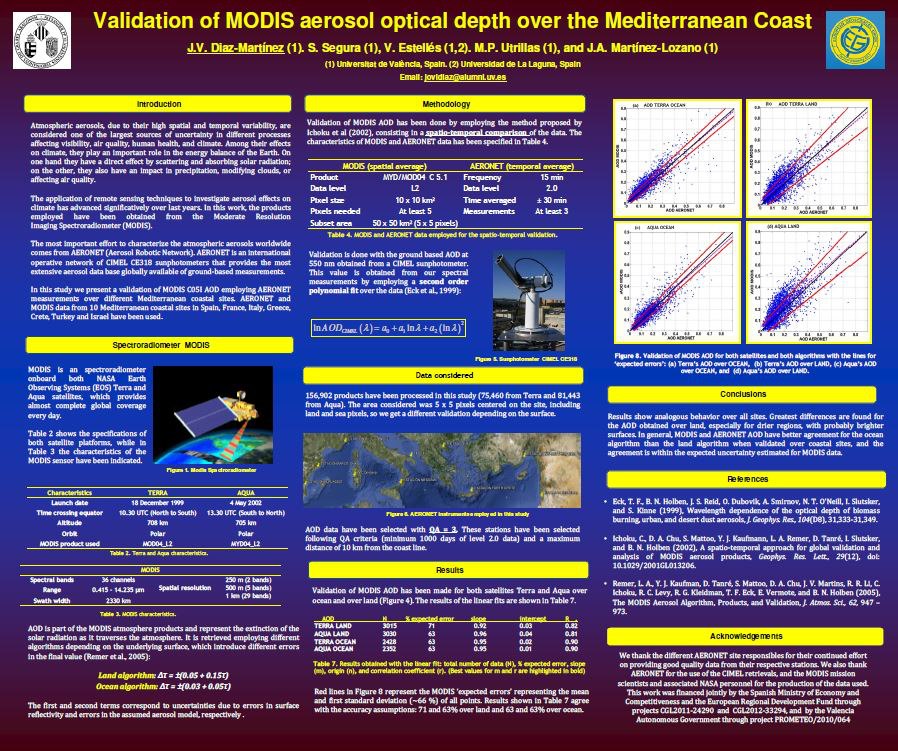
In this study we present a validation of MODIS C051 AOD employing AERONET measurements over different Mediterranean coastal sites centered over an area of 50 x 50 km2, which includes both pixels over land and ocean. The validation is done comparing spatial statistics from MODIS with corresponding temporal statistics
from AERONET, as proposed by Ichoku et al. (2002). Eight Mediterranean coastal sites (in Spain, France, Italy, Crete, Turkey and Israel) with available AERONET and MODIS data have been used. These stations have been selected following QA criteria (minimum 1000 days of level 2.0 data) and a maximum distance of 8 km from the
coast line.
Results of the validation over each site show analogous behaviour, giving similar results regarding to the accuracy of the algorithms. Greatest differences are found for the AOD obtained over land, especially for drier regions, where the surface tends to be brighter. In general, the MODIS AOD has better a agreement with AERONET retrievals for the ocean algorithm than the land algorithm when validated over coastal sites, and the agreement is within the expected uncertainty estimated for MODIS data.
References:
– C. Ichoku et al., “A spatio-temporal approach for global validation and analysis of MODIS aerosol products”, Geophysical Research Letters, 219, 12, 10.1029/2001GL013206, 2002.


Deja un comentario